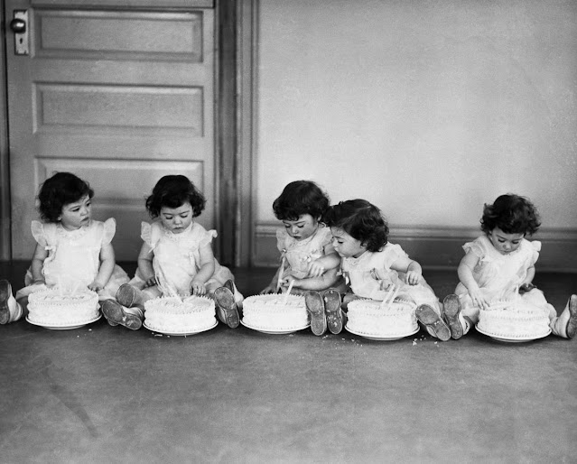
July 18, 2025
January 3, 2023
Ontario in the 1950s Through Amazing Color Photos
![]() |
Mrs. George Baxter lacing a beaver pelt into a drying frame. Overhead hangs half of a tanned moosehide, Washi Lake, Ontario, 1951 |
![]() |
51 St. Cyril's and St. Methodius' Ukrainian Catholic Church, on the Queen Elizabeth Way, near St. Catharines, Ontario, 1951 |
![]() |
Canoe lessons, Ontario, 1952 |
![]() |
Garden in front of Queen's Park, Toronto, Ontario, 1952 |
![]() |
Picnickers at Aubrey Falls, Ontario, 1952 |
September 6, 2021
Here’s the Earliest Known Image of Women’s Hockey, ca. 1890
![]() |
Portrait of Lady Isobel Stanley. |
June 14, 2021
A Series of Photographs of Downtown Belleville, Ontario in 1975
![]() |
Building on Bridge Street East in Belleville west of the TD Bank. The Wonder Shoppe was at 6, H & R Block at 8 and McKnight's Variety at 10 Bridge St. East, between Front Street and the Moira River |
![]() |
160 and 162 Front Street, Belleville, Ontario, with Cablevue office at 160 |
![]() |
160, 162 and 166 Front Street, Belleville, Ontario. The Corbin Lock building on Coleman Street is visible through the passage way |
![]() |
166 and 168 Front Street, Belleville, Ontario |
![]() |
186, 188, 190 and 192 Front Street, Belleville, Ontario (the Lister Block). Businesses included Lots o'Leather, Davison & Davison Travel and the Modern Café |
![]() |
194, 196 and 200 Front Street, Belleville. Businesses included McKinney Insurance and Central Taxi which was located on the southwest corner of Bridge and Front Streets |
December 29, 2020
The Bloor Viaduct During Construction Through Amazing Photos
The Prince Edward Viaduct System, commonly referred to as the Bloor Viaduct, is the name of a truss arch bridge system in Toronto, Ontario, Canada, connecting Bloor Street East, on the west side of the system, with Danforth Avenue on the east.
![]() |
The Bloor Viaduct during construction |
The system includes the Rosedale Valley phase (a smaller structure, referred to as the Rosedale Valley Bridge, carrying Bloor Street over the Rosedale Ravine) and the Sherbourne Phase, an embankment built to extend Bloor Street East to the Rosedale Ravine from Sherbourne Street. The Don Valley phase of the system, the most recognizable, spans the Don River Valley, crossing over (from west to east) the Bayview Avenue Extension, the Don River, and the Don Valley Parkway.
The roadway has five lanes (three eastbound and two westbound) with a bicycle lane in each direction. The subway level connects Broadview Station in the east with Castle Frank and Sherbourne Stations to the west.
This selection of pictures, taken during the construction of the Bloor Street East viaduct (1915-1917), comprises some of the images in the Canadian Historical Picture Collection, housed in the Special Collections department at Toronto Reference Library.
![]() |
Pier D. Training... First Construction... |
![]() |
Break in Sheeting. East End N2. Pier D |
![]() |
Don in Flood |
![]() |
Don Sec. East Approach |
![]() |
Don Sec. Pier B. Forms |
October 13, 2020
Pictures of Veronica Foster – Ronnie the Bren Gun Girl and the Beautiful Woman War Worker of Canada in World War II
Foster worked for John Inglis Co. Ltd producing Bren light machine guns on a production line on Strachan Avenue in Toronto, Ontario. She can be seen as the Canadian precursor to the American cultural icon Rosie the Riveter.
She became popular after a series of propaganda posters were produced; most images featured her working for the war effort, but others depicted more casual settings like Foster dancing the jitterbug or attending a dinner party. In her most famous photograph, Ronnie sports curve-hugging overalls while effortlessly exhaling smoke from her cigarette as she admires her recently assembled Bren gun.
As the perfect blend of femininity and female liberation, Ronnie became the subject of public infatuation, so much so that the United States decided to create its own female war icon. And so Ronnie’s head scarf and can-do attitude was transferred to the well-known American propaganda image of “Rosie the Riveter.”
September 22, 2020
Women Testing the Guns They Made for World War II at the Inglis Munitions Plant in Ontario, Canada, 1944
![]() |
(Photo: Toronto Star Archives) |
John Inglis and Company was a Canadian manufacturing firm which made weapons for the United Kingdom and British Commonwealth military forces during the World War II era, then later became a major appliance manufacturer. Whirlpool Corporation acquired control of Inglis in 1987 and changed the company's name to Whirlpool Canada in 2001.
The Inglis name has a proud heritage in Canada. In 1859, armed with metalworking and pattern-making skills learned in England and Scotland, John Inglis moved to Guelph, Ontario and started Mair, Inglis and Evatt which built machinery for grist and flour mills.
In 1881, operating under the name John Inglis and Sons, the company moved to facilities on Strachan Avenue in Toronto. But in 1898, with the enterprise growing madly, John Inglis died. William, one of John’s five sons, assumed leadership of the business. In 1902, he led the company into the manufacture of marine steam engines and waterworks pumping engines, and he discontinued production of its previous product line.
When William Inglis died in 1935, the new Toronto Island Ferry was named after him in appreciation of his significant contribution to the city’s industrial and cultural progress.
Two years later, an American named Major J.E. Hahn, purchased the company and made significant changes to its operations. Under Major Hahn’s leadership, the company assisted in the World War II effort by manufacturing guns for the Canadian and British governments. More than 17,800 people were employed at this time creating the need for expansion at the Strachan Avenue plant.
When the war ended in 1946, the company began to manufacture consumer products for the first time. Fishing tackle, house trailers, oil burner pumps and domestic heaters and stoves were among the diverse products offered.
August 11, 2020
Canadian Police Officer Guarding the Pharmacy in Waist-High Flood Waters in Galt, Ontario, 1974
![]() |
Const. John Shuttleworth wore waders as he stood waist-deep in Cambridge on May 17, 1974. (Mike Hanley/Canadian Press) |
Pots and pans floated out the back door of George’s Chinese restaurant. Shoes of all styles and sizes bobbed around like little leather canoes, riding the rising rapids out of The Right House department store. Const. Jack Shuttleworth stood stoically at the submerged corner of Ainslie and Dickson streets.
He stared straight ahead as the Grand River washed through downtown Galt with surreal ferocity early on a blue-sky afternoon on the 17th of May. He watched the furious flow of the Great Flood of 1974. Power boats, fences and cars spun by in the waist-deep water.
The waders he borrowed from a downtown sporting goods store kept him dry. His presence let the soggy citizens of the newly created City of Cambridge — a melding of Galt, Preston and Hespeler — know the law still existed in the sunshine of the swirling mayhem.
“The whole idea was to be a deterrent,” Shuttleworth once recalled. “So nobody would be picking this stuff off.”
(via The Spec)
May 5, 2020
Vintage Found Photos Show the Architecture of Toronto in the Late 1850s
Toronto was designated as the capital of the province of Ontario in 1867 during Canadian Confederation. The city proper has since expanded past its original borders through both annexation and amalgamation to its current area of 630.2 km2 (243.3 sq mi).
Toronto is also known for its many skyscrapers and high-rise buildings, in particular the tallest free-standing structure in the Western Hemisphere, the CN Tower.
Here below is a set of 12 cards from John Rochon that shows buildings of Toronto, ON around 1858 or 1859. They were found at a flea-market decades ago complete with cover and booklet.
![]() |
King Street, Toronto, ON, circa 1858-59 |
![]() |
Masonic Hall Buildings, Toronto, ON, circa 1858-59 |
![]() |
Mechanics Institute and St. James Parochial School, Toronto, ON, circa 1858-59 |
![]() |
Normal School Buildings, Toronto, ON, circa 1858-59 |
![]() |
Provincial Exhibition Buildings, Toronto, ON, circa 1858-59 |
December 26, 2017
33 Amazing Photos That Capture Everyday Life of Ontario, Canada in the Late 19th Century
A rogue photographer, Sallows did not wait for clients to enter his studio. He took his camera everywhere: in his black Ford Model A truck, in a hired canoe and on the newly installed trains that crisscrossed Canada between 1881 and 1937.
He sold his photographs to his studio patrons in Goderich, Ontario, the Canadian, Albertan and Ontario governments, postcard and lithograph companies in the United States, Britain, Scotland and Germany as well as magazines and newspapers in Canada, the United States and abroad. One of his photographs, Patriarch of the Flock, was published in the National Geographic magazine in 1920.
His versatility at both setting a scene and capturing a moment made him an excellent freelance photographer in an age when such a concept was barely emerging. To be a photographer between 1881 and 1937 was to be a scientist, savvy businessman and artist. Reuben R. Sallows was all three.
In 1937, Reuben Sallows, on his way to take a photograph at a school camp on the lakeshore highway, was killed when his car overturned just south of Kintail. He was 82 years old.
During his sixty year career, his artistic skill was proudly heralded locally as "Sallowsgraphs" and recognized internationally, securing him a reputation for being a "photographic genius."
These photos that Sallows captured everyday life of Ontario, Canada from between the 1860s and 1890s.
![]() |
A boy holding a stick contemplates hitting backside of a large man |
![]() |
At home |
![]() |
Bathing in Lake Huron |
![]() |
Becklers Mills Falls, Benmiller |
![]() |
Bend in Maitland River |
November 11, 2017
Incredible Photos That Capture the Ruins of Sarnia, Ontario After the Tornado in 1953
Take a look at these incredible photos from John Rochon to see what Sarnia, Ontario looked like just after the tornado in 1953.
![]() |
Christina St. looking south from Lochiel St. |
![]() |
Clean-up work on the Vendome Hotel |
![]() |
East side of Christina St. looking south to Cromwell St. |
![]() |
East side of Front St. between Lochiel and Cromwell Sts. showing tornado damage to the Barr building and the Mackenzie-Milne building |
![]() |
East side of Front St. just south of Bank of Commerce |
September 25, 2016
Ottawa Over 100 Years Ago – 40 Rare Photos Show the Capital City of Canada Before 1900
The city is the most educated in Canada, and also has the highest standard of living in the nation and low unemployment.
Here below is what Ottawa looked like before 1900.
![]() |
Elgin St. from Wellington with the City Hall on the left background, ca. 1890s |
![]() |
Entrance to the Rideau Canal, ca. 1890s |
![]() |
Family at Majors Hill Park, 1894 |
![]() |
Home for friendless women, Wellington St. 1891 |
![]() |
Horse drawn cab stand in front of the East Block, 1897 |