The 1965 floods of the South Platte River basin swept through the Front Range and Eastern Plains of Colorado leaving 21 dead, 250,000 acres inundated and $540 million in damage. Heavy rains on four consecutive days in three different areas of the South Platte basin caused flooding from Plum Creek, south of Denver, to the Nebraska state line.
The storms took place over the Greeley-Sterling area, the Plum Creek and Cherry Creek basins and the Kiowa and Bijou Creeks near Deer Trail on June 14-17, causing floods in 15 counties.
The main flood through the metro Denver area on June 16 originated in the Plum Creek basin after 14 inches of rain fell south of Castle Rock. By the time the runoff reached Sedalia, the water widened East Plum Creek from 3 feet to nearly a mile. The wall of rushing water swept away trees, houses, cars and livestock before plunging into the South Platte below Littleton.
The violent waters reached Littleton, Englewood and Denver at about 8 p.m., destroying 120 houses and damaging 935. Two hundred eighty mobile homes were lost and 16 bridges in Denver were demolished.
After the flood, Chatfield and Bear Creek reservoirs were built to control storm waters.
Take a look at these photos from Douglas County History Research Center to see what Colorado looked like during one of the worst floods in its history hit.
 |
| Destroyed automobile in silt north of Castle Rock, Colorado |
 |
| Destroyed guardrail north of Castle Rock, Colorado |
 |
| Flood damage - East Plum Creek near I/25 and Wolfensberger Road looking south |
 |
| Flood damage - East Plum Creek near I/25 and Wolfensberger Road |
 |
| Flood damage near Sedalia, Colorado, looking northwest |
 |
| Flood damage near Sedalia, Colorado, looking northwest |
 |
| Flood damage near Sedalia, Colorado, looking southeast |
 |
| Flood damage with debris washed into a concrete foundation near Plum Creek at Sedalia, Colorado |
 |
| Flood damage, Plum Creek at Sedalia, Colorado, looking east |
 |
| Flood damaged buildings near Sedalia, Colorado |
 |
| Flood damaged buildings near Sedalia, Colorado |
 |
| Flood damaged buildings near Sedalia, Colorado |
 |
| Flood damaged buildings near Sedalia, Colorado |
 |
| Flood in and around the Larkspur area |
 |
| Flood in and around the Larkspur area |
 |
| Flood in and around the Larkspur area |
 |
| Flood in and around the Larkspur area |
 |
| Flood in and around the Larkspur area |
 |
| Flood in and around the Larkspur area |
 |
| Floodwaters - East Plum Creek near I-25 and Wolfensberger Road |
 |
| Floodwaters of Plum Creek at the bridge looking east toward Sedalia, Colorado |
 |
| Floodwaters of Plum Creek near Sedalia, Colorado looking east |
 |
| Floodwaters of Plum Creek near Sedalia, Colorado looking north |
 |
| Floodwaters of Plum Creek near Sedalia, Colorado looking west |
 |
| Floodwaters of Plum Creek near Sedalia, Colorado |
 |
| Hier Drilling on Highway 85 north of Castle Rock, Colorado |
 |
| Looking east across East Plum Creek south of Wolfensberger Road |
 |
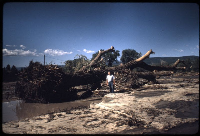
| Man standing near huge uprooted tree near Sedalia, Colorado, looking west |
 |
| Plum Creek near Sedalia, Colorado, looking east, Highway 67 bridge |
 |
| Plum Creek near Sedalia, Colorado, looking east, Highway 67 bridge |
 |
| Plum Creek near Sedalia, Colorado, looking west, Highway 67 bridge |
 |
| Plum Creek near Sedalia, Colorado, looking west, Highway 67 |
 |
| View from Castle Rock, Colorado, to the north after the 1965 flood |
 |
| View of Sedalia, Colorado, looking east from area of Highway 105 and 67 |
 |
| View of Sedalia, Colorado, looking east from Highway 67 bridge |
 |
| View of Sedalia, Colorado, looking west from area of Highway 105 and 67 |
 |
| Damage to Interstate 25-Highway 85 in the 1956 flood |
 |
| Damage to Interstate 25-Highway 85 in the 1956 flood |
 |
| Damage to trailer homes from the 1965 flood |
 |
| Damage to Wolfensberger Road bridge in the 1965 flood |


