Bring back some good or bad memories


ADVERTISEMENT
Showing posts with label Cornwall. Show all posts

June 14, 2026

The Real Cornwall: Everyday Scenes From the 1960s

The 1960s was a transformative decade for Cornwall, capturing a fascinating moment when the region still retained much of its traditional character while slowly embracing modern life. Taken by Adrian Gee, these authentic photos reveal the everyday reality of Cornish life beyond the tourist trails: from fishing villages and bustling harbors to quiet country lanes, local markets, and families going about their daily routines.

Far from the romanticized images of dramatic cliffs and golden beaches, these scenes show the true heart of Cornwall: hardworking fishermen, shopkeepers, schoolchildren, and residents living in a rugged yet beautiful corner of England during a time of gentle change. This collection offers a warm, nostalgic, and honest glimpse into the real Cornwall of the 1960s.

Hannafore point hotel, Looe, Cornwall, 1966

Ferryman, Fowey, Cornwall, 1966

Harbour, Polperro, Cornwall, 1966

Harbour, Polperro, Cornwall, 1966

Harbour, Polperro, Cornwall, 1966

March 8, 2026

40 Wonderful Photochrom Prints of Cornwall in the Late 19th Century

In the late 19th century, Cornwall was a land of dramatic contrast, where the rugged industrial heritage of tin mining met the emerging allure of the “Cornish Riviera.”

As the deep shafts of the Levant and Botallack mines began to fall silent, the region reinvented itself through the arrival of the Great Western Railway, which brought Victorian travelers to its jagged Atlantic shores for the very first time. This era was defined by a unique, salt-aired romanticism, a world of whitewashed fishing cottages in St. Ives, the mystical silhouette of St. Michael’s Mount, and the bustling harbors of Penzance crowded with traditional luggers.

Life in Cornwall during this period was deeply tied to the rhythms of the sea and the soil. While the fishing fleets hauled in vast catches of pilchards, a new generation of artists, most notably the Newlyn School, flocked to the coast, captivated by the extraordinary clarity of the light and the raw, honest lives of the local people.

These wonderful Photochrom prints of late 19th-century Cornwall capture a fleeting moment in history: a maritime kingdom caught between its ancient Celtic roots and the burgeoning modern world, all framed by the restless, turquoise waters of the Celtic Sea.

Boscastle, the village street, Cornwall, England, circa 1890s

Boscastle, view from New Road, Cornwall, England, circa 1890s

Bedruthan Steps, Cornwall, England, circa 1890s

Boscastle and Forraburg, Cornwall, England, circa 1890s

Boscastle, harbor looking west, Cornwall, England, circa 1890s

September 13, 2024

Cornwall in 1962 Through Beautiful Photos

Cornwall is a ceremonial county in South West England. It is recognised by Cornish and Celtic political groups as one of the Celtic nations, and is the homeland of the Cornish people. The county is bordered by the Atlantic Ocean to the north and west, Devon to the east, and the English Channel to the south. The largest settlement is Falmouth, and the county town is the city of Truro.

The county is rural, with an area of 1,375 square miles (3,562 km2). It is the westernmost part of the South West Peninsula. Its coastline is characterised by steep cliffs and, to the south, several rias, including those at the mouths of the rivers Fal and Fowey. It includes the southernmost point on Great Britain, Lizard Point, and forms a large part of the Cornwall National Landscape. The national landscape also includes Bodmin Moor, an upland outcrop of the Cornubian batholith granite formation.

The county contains many short rivers; the longest is the Tamar, which forms the border with Devon. These beautiful photos were found by Torfaen Corvine that show Cornwall in 1962.

Boscastle, Cornwall, 1962

Boscastle, Cornwall, 1962

Boscastle, Cornwall, 1962

Boscastle, Cornwall, 1962

Boscastle, Cornwall, 1962

September 28, 2022

32 Black and White Photos of Cornwall in the Early 1970s

Cornwall is a historic county and ceremonial county in South West England. It is recognized as one of the Celtic nations, and is the homeland of the Cornish people. Cornwall is bordered to the north and west by the Atlantic Ocean, to the south by the English Channel, and to the east by the county of Devon, with the River Tamar forming the border between them. Cornwall forms the westernmost part of the South West Peninsula of the island of Great Britain. The administrative centre of Cornwall is Truro, its only city.

Cornwall is noted for its geology and coastal scenery. A large part of the Cornubian batholith is within Cornwall. The north coast has many cliffs where exposed geological formations are studied. The area is noted for its wild moorland landscapes, its long and varied coastline, its attractive villages, its many place-names derived from the Cornish language, and its very mild climate. Extensive stretches of Cornwall's coastline, and Bodmin Moor, are protected as an Area of Outstanding Natural Beauty.

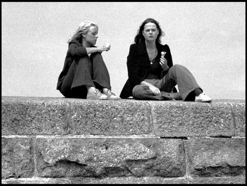
These black and white photos were taken by Norman Craig that show life of Cornwall in 1973.

Ice cream on the sea wall, 1973

Look out, here comes the bus, Mousehole, 1973

Blue Aquarius, 1973

Cornwall, 1973

Cornwall, 1973

June 26, 2021

40 Amazing Photographs Capture Everyday Life of St. Ives From the Late 19th Century

Incorporated by Royal Charter in 1639, St Ives is a seaside town, civil parish and port in Cornwall, England. The town lies north of Penzance and west of Camborne on the coast of the Celtic Sea.

In former times it was commercially dependent on fishing. The decline in fishing, however, caused a shift in commercial emphasis, and the town is now primarily a popular seaside resort.

These amazing photos from malcolm osman that documented life of St. Ives in the 1890s.

Looking down Tregenna Hill toward Tregenna Place, St. Ives, Cornwall

A busy scene in the harbour showing the seine boats offloading their catch of pilchards, which were then taken by horse and cart to the fish cellars for processing, St. Ives, Cornwall

A fisherman makes his way along Virgin Street, St. Ives, Cornwall

A group of pilchard processing workers outside a fish cellar or "fish palace" somewhere in the back streets of St. Ives, Cornwall

A view across the harbour showing Smeaton's Pier and lighthouse, St. Ives, Cornwall

A view from the east showing Porthminster beach, Pedn-Olva mine engine house and the harbour, St. Ives, Cornwall

November 17, 2017

Hot Pants for Men in 1971

TV reporter Del Cooper is in Launceston in Cornwall modeling the latest fashion for men in the skimpy shape of the hot pant. The reporter chooses a quiet Cornish market town to unleash the sight of his legs on unsuspecting shoppers with some surprising objectifying comments! Several designers and fashion houses launch short shorts including Dorothée Bis, Krizia’s Mariuccia Mandelli and Mary Quant.


Hotpants as a must-have fashion item really take off in 1970 and help symbolise the decade. They have made a fashion appearance in most decades ever since but after a seventies heyday of hotpants for men, mostly the cut-off jean version, they never really returned as short as the originals and always remain more popular as an item of clothing for women. The fashion did spill over into sportswear with shorts getting tighter and shorter. The advent in the eighties of low-rise baggy long shorts thought to have come from children in the USA wearing second hand clothes or oversized hand-me-downs took hot pants for men off the fashion agenda.

(©South West Film & Television Archive, via British Film Institute)

August 9, 2013

24 Color Photos of Cornwall, England More Than 100 Years Ago

Cornwall is a unitary authority and ceremonial county of England, within the United Kingdom. Cornwall is a peninsula bordered to the north and west by the Celtic Sea, to the south by the English Channel, and to the east by the county of Devon, over the River Tamar. The administrative centre, and only city in Cornwall, is Truro.

Cornwall forms the westernmost part of the south-west peninsula of the island of Great Britain, and a large part of the Cornubian batholith is within Cornwall. This area was first inhabited in the Palaeolithic and Mesolithic periods. It continued to be occupied by Neolithic and then Bronze Age peoples, and later (in the Iron Age) by Brythons with distinctive cultural relations to neighbouring Wales and Brittany. There is little evidence that Roman rule was effective west of Exeter and few Roman remains have been found.

Here’s a collection of 24 color photos of Cornwall, England from ca. 1895:


FOLLOW US:
Facebook • Tumblr • Pinterest • Instagram

CONTACT US


Browse by Decades

Popular Posts

Advertisement

09 10