The photographs in this collection were chiefly created by American photographers Carleton E. Watkins (1829-1916) and William Henry Jackson (1843-1942), and the images document various locations in the American West.
Photographs by Watkins consist of images created in the states of California and Oregon, and in Arizona, Montana, Utah, Washington, and Wyoming Territories, circa 1874-1890.
Most of the images created by William Henry Jackson depict locations and geological features in Colorado, while other images show locations in Utah, Idaho, New Mexico, and Oregon, 1878-1898.
 |
| Residences and wine houses of Lake Vineyard, San Gabriel, Sierra Madre Mountains, 1874-80. (Photo by Carleton E. Watkins) |
 |
| Cascades at Soda Springs, near Central Pacific Railroad, 1874-80. (Photo by Carleton E. Watkins) |
 |
| View of a Palm Tree in the orchard at the San Gabriel Mission, 1874-80. (Photo by Carleton E. Watkins) |
 |
| A individuals sit on horseback in the Garden of the Gods near sandstone rock formations identified as Cathedral Spires, Colorado Springs (El Paso County), Colorado. Shows a dirt road and trees, 1878-98. (Photo by William Henry Jackson) |
 |
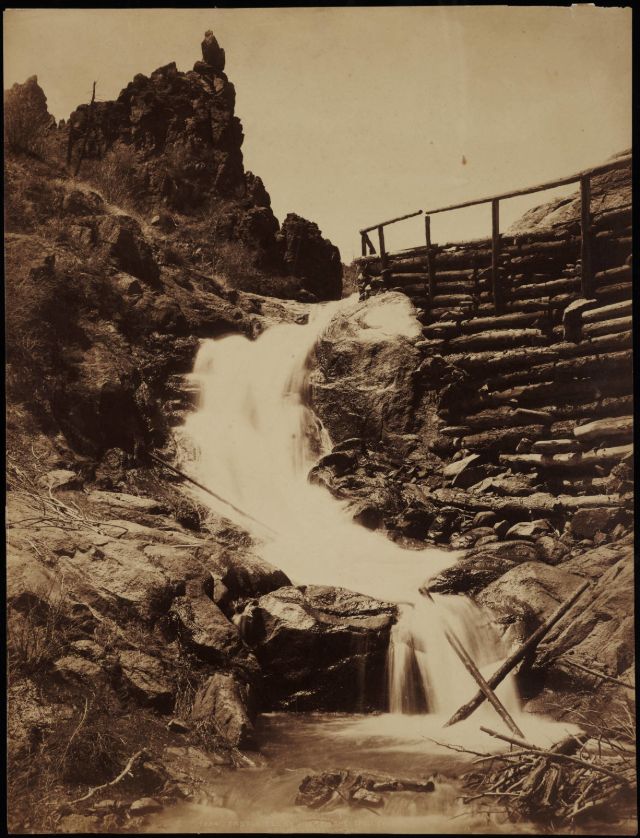
| A man and horse stand on a log bridge by a waterfall identified as Sheltered Falls on Ruxton Creek, El Paso County, Colorado. Shows the trail to Pikes Peak, 1878-98. (Photo by William Henry Jackson) |
 |
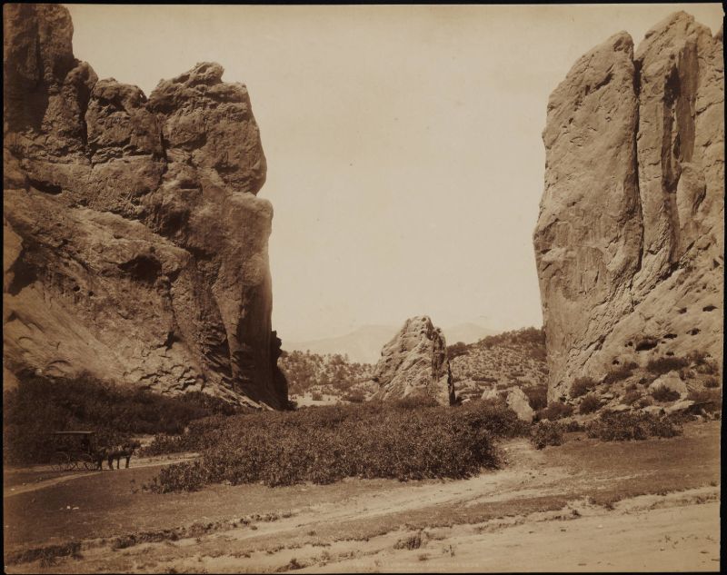
| A man in a horse-drawn carriage stops near Gate Rock, massive sandstone rock formations at the Garden of the Gods, Colorado Springs (El Paso County), Colorado, 1878-98. (Photo by William Henry Jackson) |
 |
| Half Dome 5000 ft. from Glacier Point, Yosemite, California, 1878-81. (Photo by Carleton E. Watkins) |
 |
| Monument Park. A man wears a suit and hat and stands near rock formations in Monument Park (El Paso County), Colorado. Shows eroded sandstone rock formations, brush and trees, 1878-98. (Photo by William Henry Jackson) |
 |
| People sit in a horse-drawn carriage on a one lane dirt road in Ute Pass, Teller County, Colorado. Shows Twin Creek, in a canyon, and Rainbow Falls, trees, and rock formations, 1878-98. (Photo by William Henry Jackson) |
 |
| Phoebe's Arch near Palmer Lake. A man sits near a natural sandstone arch rock formation identified as Phoebe's Arch, near Palmer Lake, El Paso County, Colorado, 1878-98. (Photo by William Henry Jackson) |
 |
| Pikes Peak from Fountain Creek, 1878-98. (Photo by William Henry Jackson) |
 |
| Sentinel Rock, Yosemite, California, 1878-81. (Photo by Carleton E. Watkins) |
 |
| The Yosemite Valley, From The Mariposa Trail, Yosemite, California, 1878-81. (Photo by Carleton E. Watkins) |
 |
| View of a sandstone rock formation identified as the Tower of Babel, the Garden of the Gods, Colorado Springs (El Paso County), Colorado. A man stands near the base of the outcrop, 1878-98. (Photo by William Henry Jackson) |
 |
| View of a waterfall identified as Castle Falls, on North Cheyenne Creek in North Cheyenne Canyon, El Paso County, Colorado, 1878-98. (Photo by William Henry Jackson) |
 |
| View of Cathedral Spires, the Platte Canyon, the South Platte River, and possibly Denver, South Park, and Pacific Railroad Company tracks, Jefferson County, Colorado, 1878-98. (Photo by William Henry Jackson) |
 |
| View of foothills and snow on Pikes Peak Austin Bluffs in El Paso County, Colorado. Trees and an eroded wash are on a hillside. A house is in a meadow beside possibly a windmill, 1878-98. (Photo by William Henry Jackson) |
 |
| View of sandstone rock formations at the Garden of the Gods, near Colorado Springs (El Paso County), Colorado. Shows a dirt road and brush, 1878-98. (Photo by William Henry Jackson) |
 |
| View of sandstone rock formations identified as the Seal and Bear in the Garden of the Gods, Colorado Springs (El Paso County), Colorado. Shows a dirt road, Pikes Peak is in the distance, 1878-98. (Photo by William Henry Jackson) |
 |
| View of Sierra Blanca, a stream and railroad tracks, possibly Costilla County, Colorado, 1878-98. (Photo by William Henry Jackson) |
 |
| View of the city of Glenwood Springs and the stone and wood frame buildings at the Yampah Hot Springs bathhouse and pool, Glenwood Springs (Garfield County), Colorado, 1878-98. (Photo by William Henry Jackson) |
 |
| View of the Denver and Rio Grande Railroad narrow gauge tracks near the Arkansas River in Royal Gorge, Fremont County, Colorado, 1878-98. (Photo by William Henry Jackson) |
 |
| View of the Denver and Rio Grande Railroad narrow gauge tracks near the Arkansas River in Royal Gorge, Fremont County, Colorado, 1878-98. (Photo by William Henry Jackson) |
 |
| View of Tutocanula Pass, Yosemite, California, 1878-81. (Photo by Carleton E. Watkins) |
 |
| Yosemite Valley from Eagle Point, Yosemite, California, 1878-81. (Photo by Carleton E. Watkins) |
 |
| View from Round Top. Cloud scene looking east from Azimuth. Vertical wall just west of Azimuth in foreground. Blue Lakes on right, 1879. (Photo by Carleton E. Watkins) |
 |
| View from Round Top. Looking along south side of ridge. Mokelumne River in left foreground. Trail on face of ridge, 1879. (Photo by Carleton E. Watkins) |
 |
| Old South Shaft Ore Quarry, Tough-nut Mine. Part of Town of Tombstone. Dragoon Mountains, with Cochise Stronghold in back-ground, Arizona, 1880. (Photo by Carleton E. Watkins) |
 |
| Ships at Dock, Port Madison, Puget Sound, Washington Territory, 1882. (Photo by Carleton E. Watkins) |
 |
| Spokane Falls, Washington Territory, 1882. (Photo by Carleton E. Watkins) |
 |
| View of a mill in Port Ludlow, Washington Territory, 1882. (Photo by Carleton E. Watkins) |
 |
| Giant Geyser, Upper Geyser Basin, Yellowstone National Park, 1884-85. (Photo by Carleton E. Watkins) |
 |
| Grotto Geyser, Upper Geyser Basin, Yellowstone National Park, 1884-85. (Photo by Carleton E. Watkins) |
 |
| Indian Village at the Head of the Dalles, Columbia River, Oregon, 1884-85. (Photo by Carleton E. Watkins) |
 |
| Pulpit Terrace, Yellowstone National Park, 1884-85. (Photo by Carleton E. Watkins) |
 |
| Rock Bluffs, Columbia River, Oregon, 1884-85. (Photo by Carleton E. Watkins) |
 |
| Tooth Bridge and Eagle Creek Crossing, Columbia River, Oregon, 1884-85. (Photo by Carleton E. Watkins) |
 |
| View of mines at Marysville, Montana, including the Maskelyne Tunnel, established 1883, of the Drumlummon mine, circa 1884. (Photo by Carleton E. Watkins) |
 |
| View of the town of Marysville, Montana, circa 1884. (Photo by Carleton E. Watkins) |
 |
| Winter on the Columbia River, Oregon, 1884-85. (Photo by Carleton E. Watkins) |


.jpg)


0 comments:
Post a Comment